
 English
 Українська
 Български
 Hrvatski
 Čeština
 Dansk
Dansk Nederlands
 Eesti
Eesti Suomi
Suomi Français
 Deutsch
 Ελληνικα
 Magyar
 Íslenska
 Italiano
 Latviešu
 Lietuvos
 Polski
 Português
 Română
 Русский
 Српски
 Slovenčina
 Slovenščina
 Español
 Svenska
 Türkçe
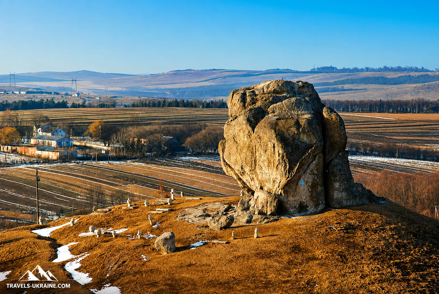
Pidkamin is one of those places in the Lviv region where it is difficult to begin its history with the traditional «the town was first mentioned in such-and-such a year.» Towering above the settlement is a huge rock approximately 17 meters high, from which the name Pidkamin derives, while opposite it, on a high hill, stands a monumental monastic complex that looks more like a fortress. That alone is enough to make the area seem unusual, but the most interesting part begins when we turn to archaeology and old documents.
People were visiting the famous Stone long before Pidkamin appeared in written sources. According to the Encyclopedia of the History of Ukraine, fragments of pottery dating from the 9th–7th centuries BCE have been found around the rock, along with materials from the Old Rus period dating from the 11th–13th centuries. At the foot of the mountain, researchers have also documented a pre-Christian ritual site arranged in a natural cave. In other words, long before the monastery walls were built, this elevation already held significance for people who lived here in various historical periods.
The settlement of Pidkamin was first mentioned in historical documents in 1441, while the first documented mention of a Dominican monastery dates to 1464. At the same time, monastic tradition placed the arrival of the monks on the hill much earlier. These accounts later gave rise to stories about an ancient sanctuary, Tatar attacks, an early monastery that was destroyed, and the mysterious past of the giant rock. Some of these narratives have an archaeological basis, while others remain later historical traditions, so in this article we will clearly distinguish confirmed facts from legends.
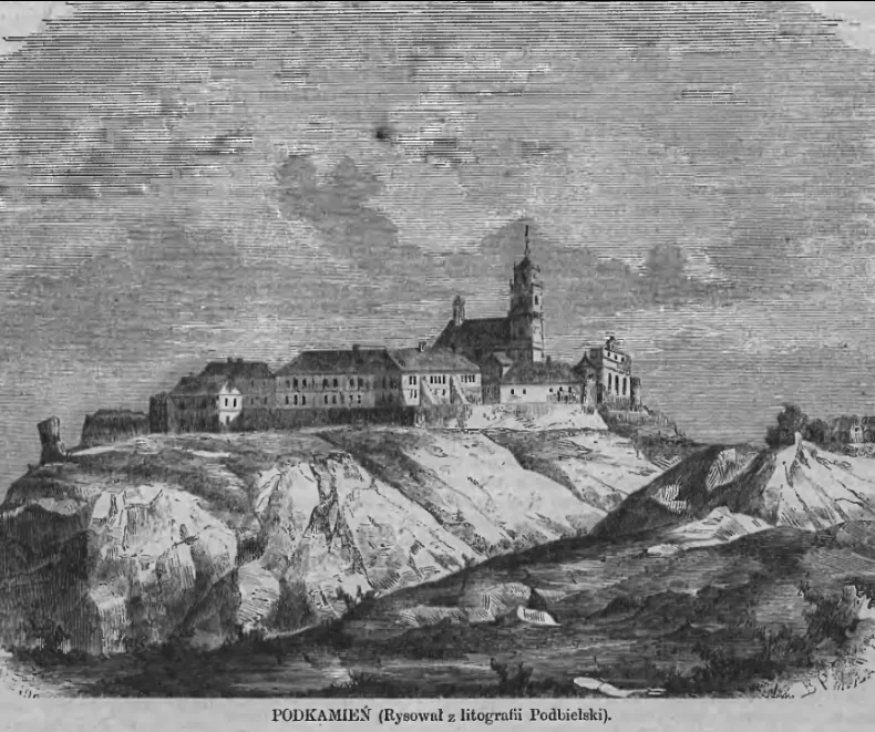
Pidkamin is also interesting because its past can be traced not only through modern reconstructions. As early as 1648, the Dominican friar Szymon Okolski published a separate old-print edition in Kraków devoted to the Holy Mountain above Pidkamin. Nearly a century later, in 1746, military engineer Christian Dahlke drew a detailed plan of Pidkamin’s fortifications, while by the end of the 18th century the monastery-fortress appeared on military maps and in travelers’ drawings.
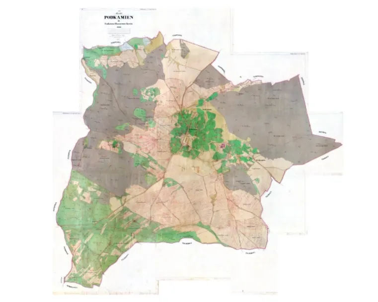
Particularly revealing is the 1844 Austrian cadastral map. It shows the market square, Pidkamin’s buildings, the fortified monastery, gardens, cemeteries, and parcels of land. But the most interesting detail is that the cartographers marked the enormous Stone itself with a separate, non-standard symbol—it was so important to the character of the area that it literally found its way onto the official cadastral plan.
For today’s traveler, this means that Pidkamin is much more than one dramatic rock. In a few hours, you can see a natural geological landmark, climb to the monastery-fortress, explore old defensive walls, caves, burials, and stone crosses, and at the same time walk through places mentioned in documents, old printed books, and maps dating back several centuries.
The main intrigue of Pidkamin lies precisely in the layering of different eras. Near the Stone, archaeologists find traces of people who lived here long before Christianity. Medieval documents already mention the settlement and monastery. In the 17th century, separate books were published about the site; in the 18th, its fortifications were drawn by military engineers; and in the 19th century, Pidkamin was documented in detail by Austrian land surveyors.
Next, we will examine this history without tourist embellishments: we will explore what is actually known about the giant Stone, whether a pre-Christian sanctuary could have existed beside it, how the monastery-fortress came into being, what old maps and drawings reveal, and what a tourist can see in Pidkamin in a single day.
The Devil’s Stone in Pidkamin: A Rock Giant and Traces of Ancient Eras
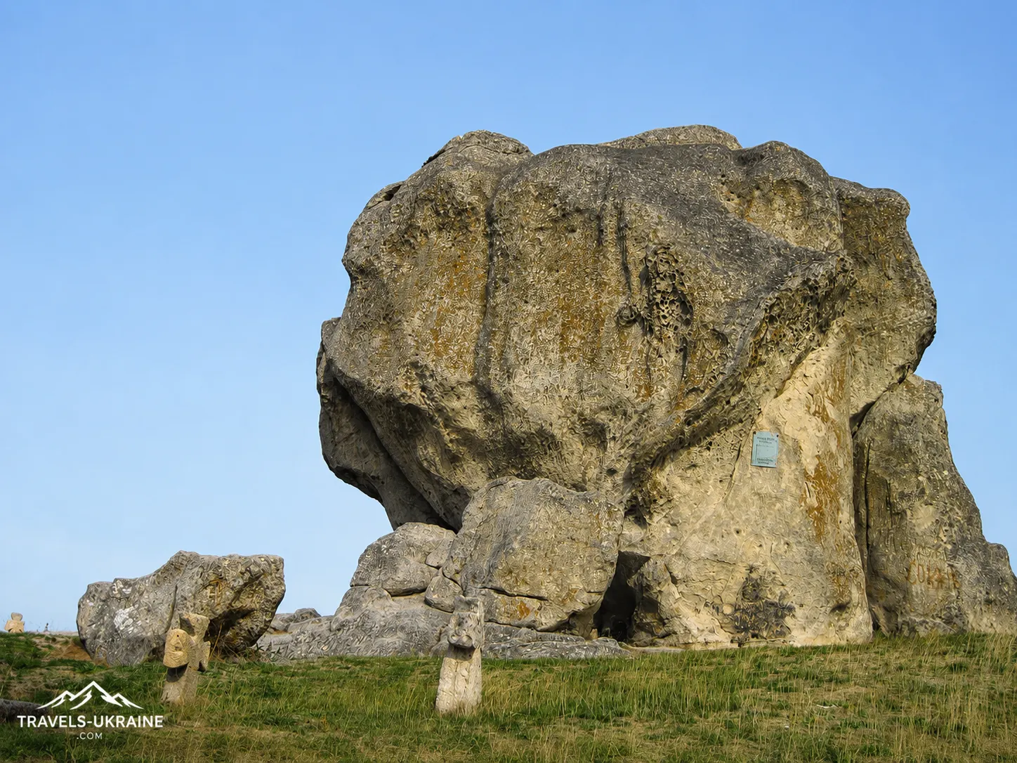
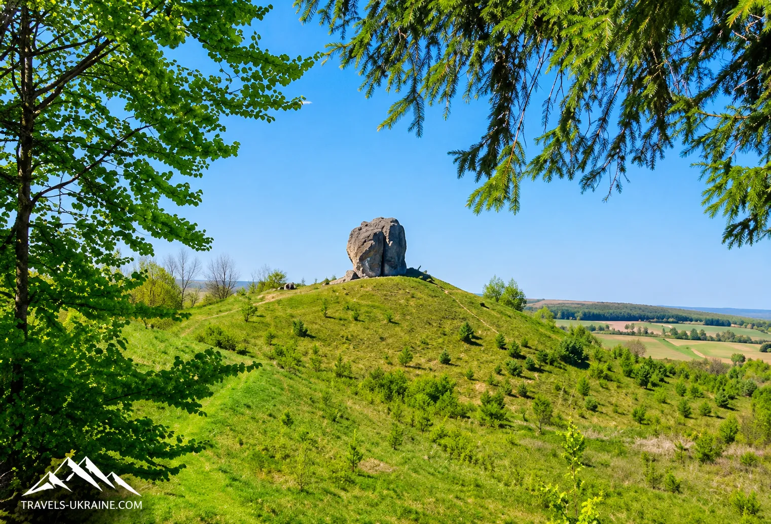
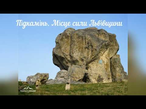
Pidkamin’s main natural landmark is so unusual that it most likely gave the settlement its name. On a high hill stands the Devil’s Stone, an imposing rock outcrop approximately 17 meters high. Against the surrounding fields and gently rolling landscape, it looks as though someone really carried a huge boulder here and left it in the middle of the countryside.
That unusual shape gave rise to numerous legends about a devil who was supposedly carrying the stone to a shrine but failed to complete his task. Yet the rock’s geological origins are far more interesting than the fairy-tale explanation. Scientific sources identify the Stone as an erosional remnant of Sarmatian age, formed from ancient sedimentary rocks. Some geological sources specify that it is an outcrop of Sarmatian sandstones of the Volyn-Podilskyi Plate.
How the Devil’s Stone Formed
Millions of years ago, the territory of modern Podillia looked entirely different. Marine sediments accumulated here, gradually compacting and turning into solid rock. After the sea retreated and the land rose, the prolonged effects of water, frost, wind, and temperature fluctuations began to wear down the surface.
Softer rocks were eroded and weathered more quickly, while more resistant sections remained. Geologists call such formations erosional remnants—fragments of once much thicker rock layers that survived the destruction of the surrounding landscape. The Stone was therefore not carried here by a glacier or by people, nor did it «fall» here as a separate boulder. It is part of an ancient geological surface, of which far less material has remained around it over time. This is what accounts for its striking solitary silhouette.
The area around Pidkamin lies in a particularly interesting geographic region: the Holohory, Voronyaky, and Kremenets Hills converge here, while to the south stretches the ridge of the Podolian Tovtry, or Medobory. Thus, even a single isolated rock forms part of the much larger geological history of Western Podillia.
What Archaeologists Found on the Rock’s Surface
In 2020, archaeologists began a new stage of research at the Pidkamin I site in the «Kamin» locality. The complex was measured in detail using surveying equipment, while the rock was studied through photogrammetry and three-dimensional models were created. During the examination, researchers documented niches, cuttings, and individual architectural elements on the Stone’s surface. This is an extremely important detail: it confirms that in the past the rock did not merely attract people’s attention but may have been directly incorporated into some kind of structures.
It was precisely these various grooves and cuttings that earlier gave rise to the assumption that wooden structures may have been attached to the rock. Older historiography even compared them with the rock construction systems known at Tustan. Modern archaeologists, however, are much more cautious: the cuttings themselves have been documented, but the exact appearance, purpose, and chronology of all the wooden structures still require further study.
Thus, statements such as «a two-story wooden fortress definitely stood on the Stone» would be too categorical today. It is much more accurate to say that the traces on the rock point to its active use by people and the probable existence of structures attached to it.
Archaeology Shows That People Came Here for Millennia
The most interesting discoveries lie not only on the surface of the Stone itself, but also around it. Modern archaeological research shows that the tract was used in various historical periods. In the scholarly catalogue, the site Pidkamin I is identified as a cemetery and Christian ritual site containing materials from the Early Iron Age, 12th–7th centuries BCE; the medieval period, 9th–10th and 12th–13th centuries; and the 17th–18th centuries.
Another archaeological site, Pidkamin IV, lies at the foot of the Stone, where materials from the Early Iron Age have been found. In neighboring areas, archaeologists have also discovered settlements from various periods and even a fortified settlement dating from the 9th–10th centuries. In total, within the boundaries of present-day Pidkamin, researchers have already counted around twelve archaeological sites—from Mesolithic and Early Iron Age sites to medieval and early modern ones.
This substantially changes how we perceive the location. We are not simply looking at a rock beside which a settlement happened to emerge. The area around the Stone attracted people for a very long time, and its functions may have changed repeatedly.
The Old Cemetery Around the Stone
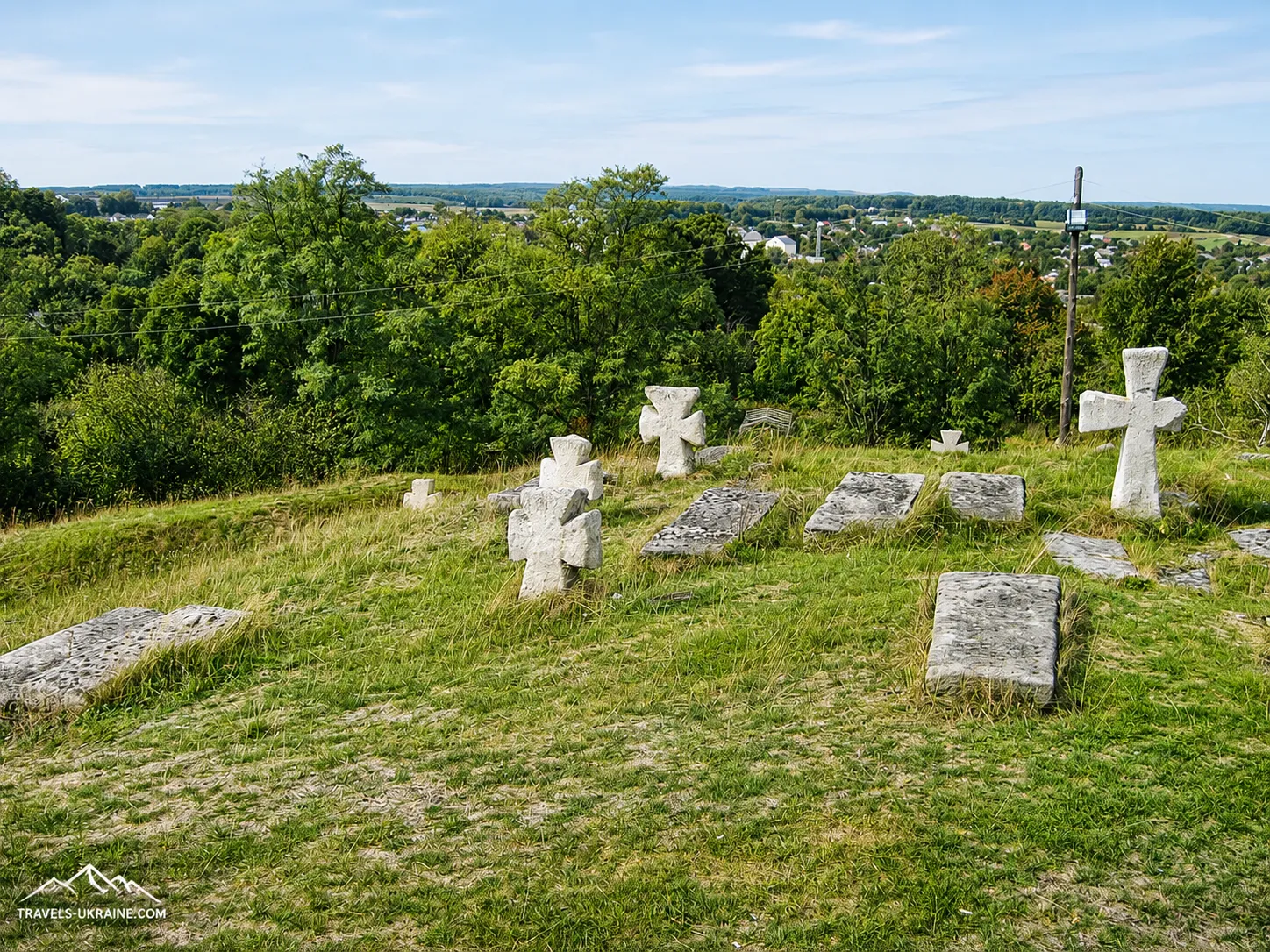
Right beside the rock, you can see the stone crosses of the old cemetery. Because of their shape, the burial site is often called the «Cossack graves» in tourist descriptions, but this name should be used with caution. Archaeological work in 2021 confirmed the existence of burials in the northern part of the complex. The two burials examined date from the 17th–18th centuries. At the same time, researchers believe that the cemetery itself may have an earlier, possibly medieval origin, although there is not yet enough concrete evidence to establish this.
It is also interesting that the burials were made in an existing ditch, which may itself date back to the medieval period. Thus, the area around the Stone was repeatedly reshaped and given new functions. For this reason, the wording «an old cemetery dating from the 17th–18th centuries» is now considerably more accurate than the categorical term «Cossack cemetery.»
The Stone Is Now Being Studied in 3D
It is particularly interesting that modern research on the site has long gone beyond ordinary archaeological sketches. Since 2020, researchers have been creating precise digital plans and 3D models of individual parts of the complex. This makes it possible to record the location of every niche, cutting, and structural detail, and then compare them with excavation results, old descriptions, and possible reconstructions.
To a tourist, this may seem like a technical detail, but it is highly significant: a site that for decades was described mainly through legends is gradually becoming a well-documented archaeological complex.
Was There an Ancient Sanctuary Beside the Devil’s Stone?
It is precisely around the Devil’s Stone in Pidkamin that the greatest number of questions arise—questions to which historians and archaeologists still have no definitive answers. The rock was used by people in different historical periods; its summit preserves niches cut into the stone and numerous traces of wooden structures, while an old monastic tradition even mentions a «pagan shrine on the rocks.»
These facts formed the basis for the hypothesis that before the Christian period, the Stone may have had sacred or funerary-ritual significance. However, it is important to draw a clear distinction: archaeologists do document ancient materials, burial niches, and traces of construction, but the claim that «a pagan sanctuary definitely existed here» remains a scholarly interpretation rather than an conclusively proven fact.
Burial Niches on the Rock’s Summit
One of the Devil’s Stone’s strangest features is the presence of rectangular niches cut directly into its upper section. Researcher Mykola Bandrivskyi described several such recesses, approximately 1.8–2.5 m long and about 0.4–0.6 m deep. Their shape and orientation led researchers to suggest that they may have been used for a funerary ritual. This interpretation is also supported by the large number of grooves, cuttings, and dressing marks around the niches—traces of structures that once stood against the rock.
According to one reconstruction, a wooden structure or shelter may have stood above the burial recesses. Its exact appearance, however, is unknown. Therefore, popular drawings of a «temple-fortress» or a large wooden building on the Stone should be regarded only as possible reconstructions, not as the reliably established appearance of the structure.
Where Did the Reference to a «Pagan Shrine» Come From?
The Dominican monastic tradition is of particular interest. According to Mykola Bandrivskyi, the chronicle of the Podkamin Dominican monastery contained a record stating that the monks who came here in the 13th century allegedly found a «pagan shrine» on the rocks. Similar information was later repeated by the 19th-century Dominican historian Sadok Barącz, who worked with monastic archives for many years and described the history of Pidkamin.
But there is a fundamental problem here: we do not have an independent 13th-century document created directly at the time of the events described. The information has come down to us through a much later monastic tradition. It is therefore valuable historical evidence of how the monks themselves explained the site’s pre-Christian past, but it cannot, by itself, prove that a specific pagan temple existed.
Could the sanctuary have been connected with nomadic peoples?
Mykola Bandrivskyi proposed an even more intriguing interpretation. He noted that the form of the burial niches, the nature of the ritual, and certain historical parallels may be connected with nomadic peoples of steppe origin who reached the Volhynia-Podolia borderland in the 11th–12th centuries.
The researcher suggests a possible connection between the complex and the Cuman milieu. According to his hypothesis, the cone-shaped hill with a huge rock at its summit may have resembled a traditional steppe burial mound to nomads and thus acquired special funerary and ritual significance.
This interpretation is intriguing, but it has not yet been conclusively proven. The archaeological complex at Pidkamin is multilayered: it contains materials from the Early Iron Age, the Kyivan Rus period, the Middle Ages, and the modern era. It would therefore be too simplistic to link all the carvings, niches, and structures to one particular culture.
The mysterious stone «baba» near Pidkamin
Bandrivskyi cites another intriguing detail in support of the possible presence of steppe peoples. According to old descriptions, until the 19th century a stone anthropomorphic statue stood near the neighboring village of Pankivtsi, and local tradition associated it with Pidkamin. It was described as a female figure wearing a distinctive headdress and clothing. These features led the researcher to compare it with the so-called stone babas—anthropomorphic sculptures characteristic of the Turkic-speaking nomadic peoples of the steppe, particularly the Cumans.
However, the statue itself has not survived to the present day in its original context, so here too we should speak only of a possible connection, not conclusive proof of a Cuman sanctuary.
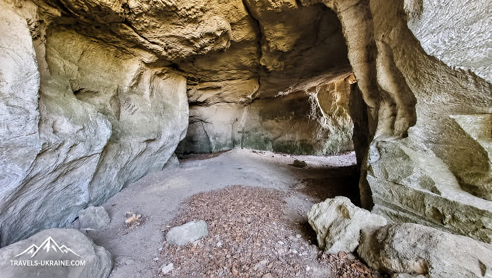
The caves beneath Monastyrska Hill
Another mysterious layer of Pidkamin lies not beside the Stone itself, but beneath Monastyrska Hill. There are two cave chambers here that local monastic tradition associates with an early monastic settlement. According to legend, monks may have settled in the caves during the princely period, while an early Christian shrine stood on the hill. Modern church-historical materials associate these caves with the 13th century and the beginnings of monastic life in Pidkamin.
Yet caution is necessary here as well. The first documented mention of the Dominican monastery dates only to 1464. Accounts of a 13th-century monastery stem from later tradition and archaeological interpretations, so they should not be presented as though a founding charter from the princely period had survived.
At the same time, the very existence of the caves makes Monastyrska Hill even more interesting to study. It shows that the sacred use of Pidkamin’s natural landscape was not limited to the gigantic rock alone.
From a pre-Christian site to a Christian shrine
The most intriguing feature of Pidkamin may be the possible continuity of the sacred landscape. Places that may have held ritual significance before Christianity later became part of Christian religious space. This phenomenon is known in various parts of Europe: an unusual mountain, spring, cave, or rock might first have been important to pre-Christian communities, and after the change of religion, the site’s sacred character did not disappear—only its interpretation changed.
Whether this is what happened in Pidkamin cannot yet be determined conclusively. But here we find, side by side, a gigantic rock bearing traces of ancient structures, burial niches, multilayered archaeological sites, caves, and a monastic tradition concerning a pre-Christian shrine. This combination certainly deserves to be taken far more seriously than the simple legend of the «Devil’s Stone.»
What can be considered fact, and what remains a hypothesis
To avoid turning the history of Pidkamin into a collection of attractive inventions, it is worth clearly distinguishing between levels of certainty.
Archaeologically confirmed: the area was used by people during various historical periods; the Stone contains carved niches, grooves, and traces of structures; burials existed around it; sites dating from the Early Iron Age, the princely period, and later centuries have been found within Pidkamin.
Historically recorded in later sources: the monastic tradition of a «pagan shrine on the rocks» and early monastic life.
Still a scholarly hypothesis: the exact function of the rock complex, its connection with the Cumans, and the possibility that a specific pre-Christian sanctuary existed here.
It is precisely this uncertainty that makes Devil’s Stone in Pidkamin so intriguing. This is not an invented «mystical spot» to which a history was attached after the fact. Before us is a real archaeological complex whose significance researchers are still working to determine.
A completely different chapter in its history began when the Dominicans established themselves on the neighboring hill and gradually created one of the largest monastic complexes in western Ukraine—the Pidkamin monastery-fortress.
Pidkamin on old maps and drawings: how the town looked 250 years ago
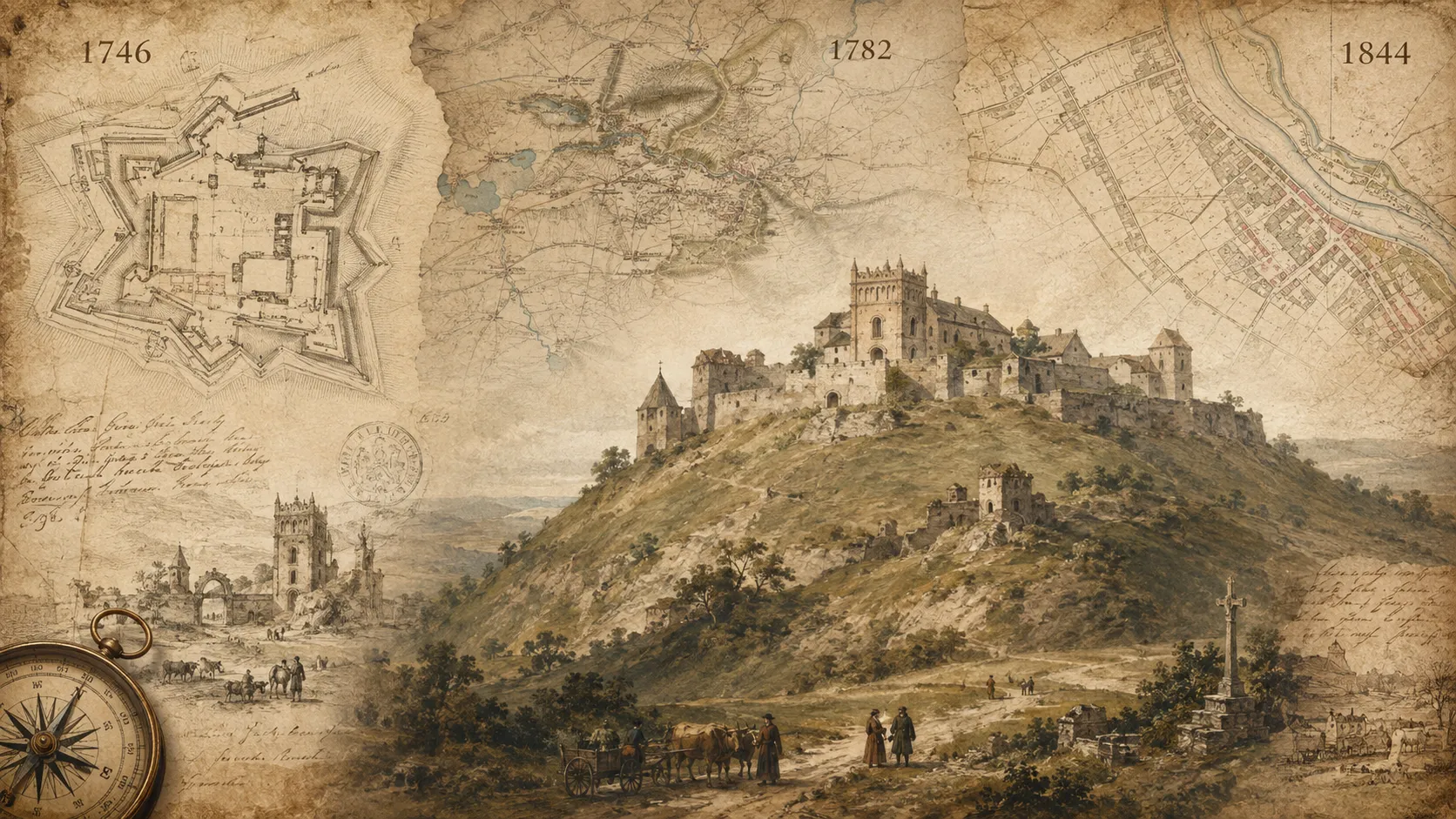
The history of Pidkamin can be reconstructed not only from written documents and archaeological finds. Old engineering plans, military maps, travelers’ drawings, and cadastral materials have survived, allowing us to see, quite literally, how the monastery-fortress, the town, and the surrounding landscape changed.
It is especially valuable that these sources were created for entirely different purposes. A military engineer was interested in defensive structures, Austrian cartographers in roads, terrain, and settlements, a traveling artist in the overall appearance of the monastery on the hill, and cadastral surveyors in every plot of land and building lot. When these materials are overlaid, 18th–19th-century Pidkamin gradually ceases to be an abstract «old town.»
1746: an engineering plan of Pidkamin Fortress
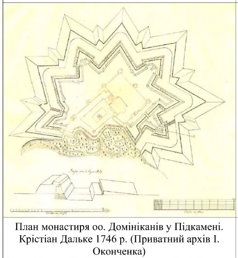
One of the most valuable cartographic sources is a document with the French title «Plan de la forteresse de Podkamien, inventé et dessiné par Chretien Dahlke... l’an 1746»—«Plan of the Pidkamin Fortress, designed and drawn by Christian Dahlke in 1746.»
The plan is particularly interesting for the way it defines the site. Its author calls the monastic complex not simply a monastery or shrine, but a forteresse—a fortress. This corresponds closely to what visitors see in Pidkamin today: the church and monastic buildings were surrounded by a separate system of defensive walls and towers.
The engineering drawing helps clarify the relative positions of the defensive perimeter, the inner buildings, and the approaches to the monastery hill. It is especially useful for modern visitors, since part of the ancient fortification system has been lost or rebuilt, making it difficult to imagine the original scale of the defenses from the ruins visible today alone.
There is also an important archival detail here: the copy now held by the National Archives in Kraków under reference number 29/663/0/6/719 is a later copy of the original 1746 plan. It is therefore more accurate to speak not of «Dahlke’s original drawing, preserved to this day,» but of an archival copy reproducing his historical plan.
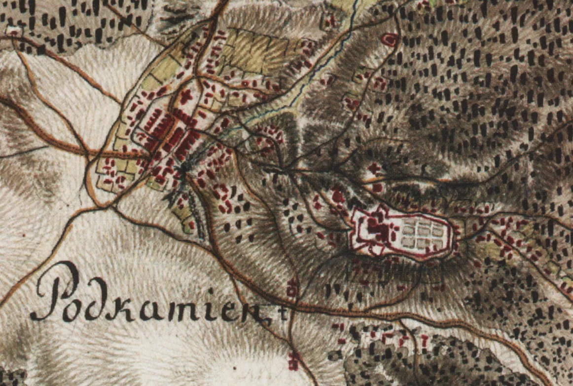
Pidkamin on the Map of Mieg, 1779–1783
After the first partition of the Polish–Lithuanian Commonwealth, Galicia came under Habsburg rule, and the new administration began systematically mapping the territories it had acquired. This led to the First Military Survey of Galicia, 1779–1783, known today as the Friedrich von Mieg map. This was not an ordinary schematic depiction of the region. The maps were created at a scale of approximately 1:28 800, so they recorded settlements, roads, rivers, forests, terrain, and important structures in considerable detail.
On this cartographic survey, Pidkamin is marked as «Miasto Podkamień»—the town of Pidkamin. It appears in sections 375–379 together with Nakwasza, Chernytsia, Popivtsi, Palykorovy, Pankivtsi, and other surrounding settlements. This is also an important detail in the history of the settlement itself. At the end of the 18th century, cartographers recorded Pidkamin not as an incidental village beside a monastery, but as an established urban center in the complex landscape of the Voronyaky.
Military maps were accompanied by descriptions of the terrain in which Austrian officers noted roads, water obstacles, forests, elevations, and important buildings. For the army, the monastery on the high hill was not only a religious center but also a prominent landmark that could not be ignored during military mapping.
1782: Pidkamin through the eyes of Johann Heinrich Müntz
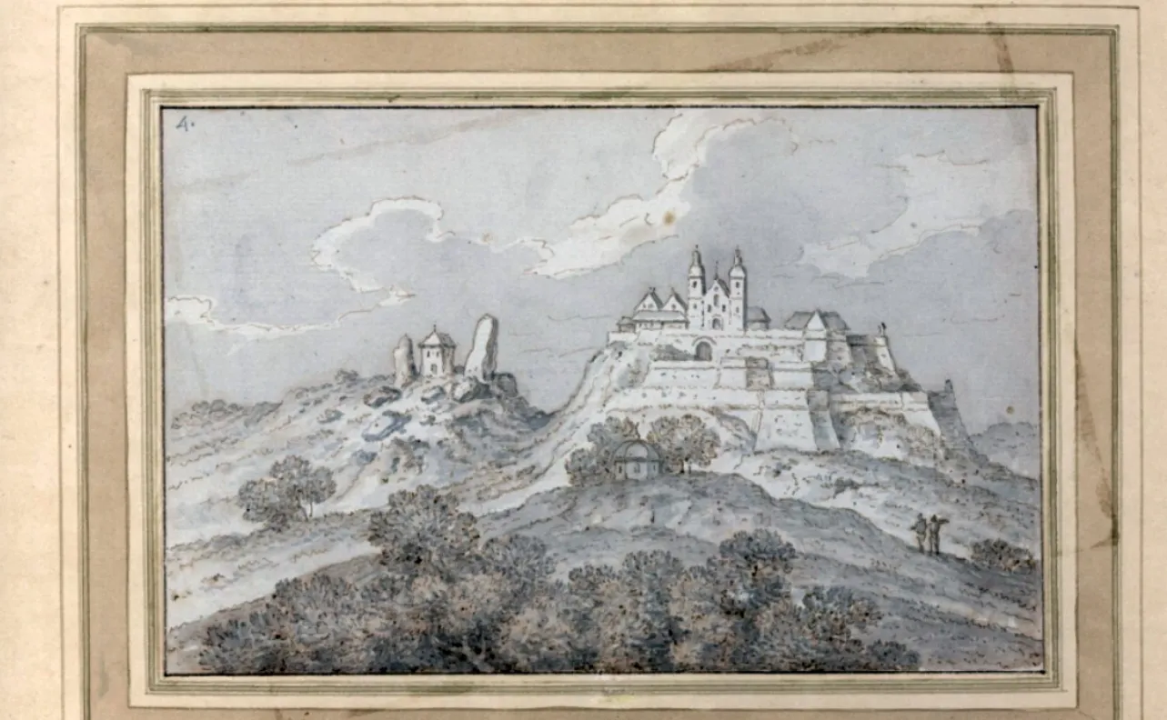
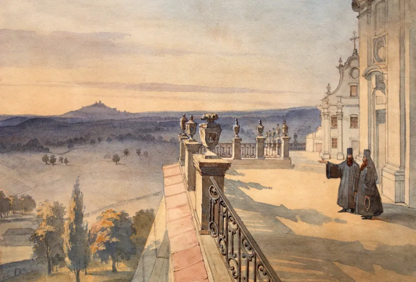
At almost the same time as the Austrian military cartographers, Pidkamin was seen and sketched by Johann Heinrich Müntz—a Swiss military engineer, artist, and traveler who journeyed through the Ukrainian lands in the second half of the 18th century. Around 1782, he created a work entitled «Podkamień. Kościół i klasztor dominikanów – widok»—«Pidkamin. A view of the Dominican church and monastery.»
In the drawing, the monastic complex rises atop the hill and clearly appears as a fortified structure surrounded by defensive walls. On the neighboring elevations, the artist depicted two smaller buildings, while an open, rolling landscape stretches all around.
For modern historical study, this drawing is exceptionally valuable. Before us is not a 21st-century restorer’s fantasy or a computer reconstruction, but an image created by someone who saw Pidkamin with his own eyes in the late 18th century.
Comparing Müntz’s drawing with contemporary photographs clearly shows how dominant the monastery was in the surrounding landscape. It literally controlled the skyline, while its defensive walls made the complex resemble a mountain citadel.
1844: Pidkamin on an Austrian cadastral plan
The town can be examined in even greater detail on the full-color cadastral map of 1844. Unlike military maps, it was created to record land and property, so literally every plot mattered here. The map shows building and land parcels, the market square, the monastic complex, gardens, roads, Christian and Jewish cemeteries. It also shows an estate with parkland and the structure of Pidkamin’s residential development.
This allows us to see the settlement as something quite different from what it looks like today. 19th-century Pidkamin had a distinct center with a market square, denser development, and several separate religious and civic spaces.
The cadastral map even marked Devil’s Stone
The most interesting detail of the 1844 map concerns the very feature from which Pidkamin takes its name. The cartographers marked a separate, non-standard symbol at the site of the giant rock. For a cadastral map whose main purpose was to record land boundaries and property, this is quite telling. Devil’s Rock was such a distinctive feature of the landscape that the surveyors considered it worth depicting separately.
This also helps dispel the assumption that the Stone’s modern significance as a tourist attraction emerged only recently. By the mid-19th century, the rock was already such an obvious geographical landmark that it had been included on official maps.
The original paper materials from this cadastral survey are now held at the Central State Historical Archive of Ukraine in Lviv, while a digital reconstruction of the map can be viewed in the Gesher Galicia mapping project.
What Changed Between the 18th and 19th Centuries
If we place the 1746 fortress plan, Münz’s drawing from around 1782, and the 1844 cadastral map side by side, we can essentially see a small visual chronicle of Pidkamin.
On Dalke’s plan, the defensive complex is the main feature. In Münz’s drawing, the monastery already appears as the dominant element of the entire surrounding landscape. Meanwhile, the mid-19th-century cadastre shows not merely a shrine, but an established town with a market, roads, gardens, cemeteries, and residential quarters.
Sources like these help avoid a common problem in historical travel articles, when an author writes that «a magnificent fortress once stood here,» leaving the reader to imagine it from a few sentences. In the case of Pidkamin, we can actually look at historical plans and images of the site.
Why old maps are worth comparing with present-day Pidkamin
For a traveler, this cartographic material can become a separate part of the journey. Before setting out, it is worth opening the 1844 cadastral map, then trying to identify the main landmarks on site: Monastery Hill, the location of the old market, the routes of the historic roads, and the Rock itself. Comparing the panorama from Monastery Hill with Münz’s drawing is particularly fascinating. Some buildings have disappeared, while the roads and vegetation have changed, but the relative positions of the hills and the main natural landmarks remain recognizable.
This is why Pidkamin is interesting not merely as a place to photograph Devil’s Rock and the monastery. Here, you can literally superimpose the modern landscape on maps and drawings from two centuries ago and see which features have survived changes of state, wars, rebuilding, and several generations of inhabitants.
Yet old maps primarily show the town’s layout and fortifications. The far more dramatic question is what happened to Pidkamin in the centuries that followed, and why the monastery, which had survived Tatar raids and numerous wars, came close to being lost forever in the 20th century.
What to see in Pidkamin in one day
It is entirely possible to explore Pidkamin in a single day, but coming here only for a photograph beside Devil’s Rock would be a mistake. Its greatest appeal lies in the combination of several distinct layers: the giant rock, ancient archaeological traces, the monastery-fortress, caves, the old cemetery, and panoramas of the surrounding uplands.
The main sights are close to one another, so most of the route can be covered on foot. It is more convenient to leave the car near one of the main tourist attractions and then explore Pidkamin at a leisurely pace. Naturally, the best starting point is Devil’s Rock—the natural landmark that effectively gave Pidkamin its name.
Up close, the rock makes a very different impression than it does in photographs. Do more than simply walk around it; examine its surface carefully: cuttings, grooves, niches, and other traces of human activity have survived here, some of which are currently being studied by archaeologists.
It is especially easy to understand at the Rock why so many legends arose around this place. A solitary giant rock on an open elevation truly looks unusual in the surrounding landscape. Do not hurry on immediately. Walk around the Rock from different sides—its shape changes noticeably depending on the viewpoint, and from some spots there is a fine view of Monastery Hill.
The old cemetery near the Rock
The area of an old cemetery surrounds the rock. Ancient stone crosses and graves have survived here, while archaeological research has confirmed the presence of burials dating from the 17th–18th centuries. Tourist descriptions sometimes refer to this place as a «Cossack cemetery,» but that name oversimplifies the history of the site. It is more accurate to call it an ancient Christian burial ground, whose individual phases of existence are still being studied.
This is not tourist scenery but a genuine burial site, so it should be visited accordingly—with no walking over graves and no attempts to move the old stones.
View the monastery from the Rock
Before heading to the monastery, it is worth finding a spot from which you can see both Devil’s Rock and the monastery-fortress on the neighboring hill. This viewpoint best explains Pidkamin’s historical structure: two elevations stand opposite each other, one crowned by a giant natural rock and the other by a large fortified monastery.
It is also one of the most interesting viewpoints in Pidkamin for photography, especially when the sun is not directly behind the monastery.
Climb up to the monastery-fortress
The route then leads to Pidkamin’s main architectural landmark—the former Dominican monastery-fortress, now belonging to monks of the Studite Rite of the UGCC. Do not limit yourself to the church. The most interesting thing here is the entire complex:
- the main monastery church, old monastic cells and buildings;
- defensive walls, towers, and remains of the fortifications;
- the monastery gate and column bearing a figure of the Virgin Mary;
- panoramic viewpoints beside the walls.
If you look at Christian Dalke’s 1746 plan before your trip, exploring the grounds becomes much more interesting. You can compare the modern monastery with the former system of fortifications and see which parts survived the centuries that followed.
One of the most common mistakes when visiting Pidkamin is to enter the church, take a few photographs in the courtyard, and move on. In fact, the scale of the fortress is best appreciated from outside. Walk along the accessible sections of the walls and view the monastery from lower points. From here, it becomes clear why the complex is called forteresse on the 1746 plan. The high hill, stone walls, and towers created a powerful defensive position long before the monastery became simply a historical monument.
The caves of Monastery Hill
The cave cavities associated with Monastery Hill deserve special attention. Local monastic tradition connects them with the early monastic life of Pidkamin. The caves add another historical layer to the route: after the giant natural rock and the Baroque fortress, the traveler finds themselves beside a much older and far less understood site.
Access to some parts of the monastery grounds may depend on services, restoration work, and monastery regulations, so before visiting the caves it is best to check the possibility of entry directly on site.
Walk through the old part of Pidkamin
After the monastery, it is worth descending into the settlement itself. Modern Pidkamin differs considerably from the town shown on the 1844 Austrian cadastral plan, but traces of its historic layout can still be followed today. It is particularly interesting to compare the present-day streets with the routes of the old roads and the approximate location of the former market center. This also helps reveal Pidkamin as more than simply a «village with a monastery»: in the past, it was a settlement with a far more important urban and commercial status.
The best route sequence
For a first introduction to Pidkamin, I would recommend this order: Devil’s Rock → old cemetery → monastery panorama → monastery-fortress → defensive walls → caves → viewpoints on Monastery Hill → old part of Pidkamin.
This route has one important advantage: the history unfolds in a roughly logical sequence. First, you see the natural rock and the earliest traces of human presence; then the medieval and early modern sacred tradition, the 17th–18th-century fortress monastery, and only afterward the historic town.
What to see near Pidkamin
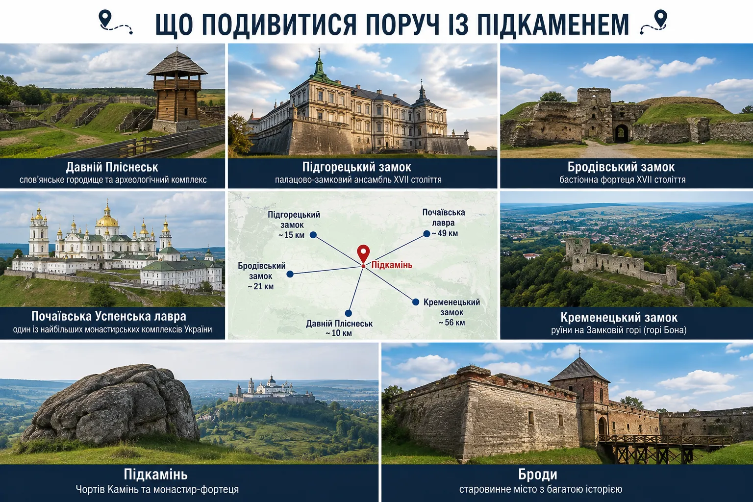
Pidkamin is well suited not only to a standalone trip but also as part of a larger route through Lviv region and northern Ternopil region. Archaeological hillforts, castles, monasteries, and historic towns whose histories intersect repeatedly are concentrated within a relatively small area around it. At the same time, there is no need to try to see everything in one day. If you explore Pidkamin without rushing, it is better to add one or two nearby sights and plan a separate tourist route for the rest.
Ancient Plisnesk—a Slavic hillfort among the Voronyaky Hills
One of the most interesting extensions to a trip to Pidkamin is the Plisnesk Archaeological Complex near the village of Pidhirtsi. This is not a single isolated ruin, but a large area where archaeologists are studying sites from several historical periods. The complex includes a Slavic cult center dating from the late 7th–10th centuries, a large hillfort from the 9th–10th centuries, an Old Rus hillfort from the 12th–13th centuries, a barrow cemetery from the 11th to the beginning of the 12th century, and an ancient monastic center.
Plisnesk is especially interesting after Devil’s Rock. At both sites, archaeology shows how vibrant life was in this frontier region long before most modern towns and villages appeared. Do not expect a classic castle with high walls. The main attraction here is the historic landscape itself: ramparts, ditches, archaeological excavation sites, and the vast territory of the ancient settlement amid the forests of the Voronyaky Hills.
Pidhirtsi Castle—a palace and fortress in one complex
Near Plisnesk stands Pidhirtsi Castle, one of the best-known historical landmarks in Lviv region. The ensemble was created in 1635–1640 for Grand Crown Hetman Stanisław Koniecpolski. Its distinctive feature is the combination of a luxurious magnate residence with bastion fortifications. The historic ensemble also includes a park, the Church of St. Joseph, and an inn courtyard.
Pidhirtsi Castle complements Pidkamin particularly well through contrast. In one place, defensive walls protected a monastery; in the other, an aristocratic residence. Both complexes took shape during roughly the same turbulent era, but served entirely different purposes.
If you are planning the route by car, Plisnesk and Pidhirtsi Castle are best visited together, as they are located essentially in the same area.
Brody—a bastion town and the remains of a powerful citadel
About two dozen kilometers from Pidkamin lies Brody, a town whose history is closely tied to trade, its position on the frontier, and fortifications. The main attraction here is Brody Castle, built in 1630–1635. The earthworks, bastions with casemates, and palace have survived from the former powerful bastion citadel.
What is especially interesting is that the castle was only part of a much larger defensive system. Its fortifications were linked to the town’s ramparts, forming a single fortified complex. Thus, after the monastery-fortress in Pidkamin, Brody reveals a different scale of defensive architecture: not a fortified sanctuary, but a planned bastion town with a separate citadel.
In addition to the castle, Brody’s old urban fabric, historic churches, and traces of the town’s multicultural past are also worth exploring.
Pochaiv — a monastic hill on Pidkamin’s horizon
In another direction from Pidkamin lies Pochaiv. The driving route between the settlements is approximately 50 km, so the two destinations can easily be combined into one full day trip. Rising above the town is the Pochaiv Assumption Lavra, one of Ukraine’s largest monastic ensembles. Its architectural centerpiece is the eighteenth-century Assumption Cathedral, and the entire complex is visible from a considerable distance.
Another aspect is especially interesting in the context of our story: Pidkamin and Pochaiv existed within the same cultural space for centuries and were both important pilgrimage centers. Their monastic hills could even be seen from distant viewpoints. That is why the Pidkamin–Pochaiv route makes sense for more than geographical reasons. It allows visitors to compare two major sacred complexes that developed near each other but belonged to different religious traditions and experienced different histories.
Kremenets — a castle hill and old town
If there is time to continue the journey after Pochaiv, the next major destination is Kremenets. It is a longer drive from Pidkamin, so Kremenets is best planned as part of a separate route together with Pochaiv. The town’s main natural and historical symbol is Castle Hill, also known as Bona Hill, crowned by the ruins of Kremenets Castle. It offers a broad panorama of the town and the surrounding Kremenets Mountains.
But Kremenets is not limited to its castle. The historic center preserves numerous sacred and civic landmarks, so it is advisable to set aside several hours for a proper first introduction to the town. In the context of Pidkamin, Kremenets is also geographically interesting: both settlements lie within the same large upland range, where the natural relief determined the locations of fortifications, monasteries, and settlements for centuries.
Which route to choose
If you have only one day, it is best not to overload the itinerary. The optimal route is: Pidkamin → Plisnesk → Pidhirtsi Castle. It offers a remarkably varied picture: Devil’s Rock and a monastery-fortress, a large Slavic and Kyivan Rus hillfort, and finally one of the best-known palace-and-castle residences in the Lviv region.
Another option is: Pidkamin → Pochaiv → Kremenets. This route is better suited to those more interested in monasteries, panoramic viewpoints, sacred architecture, and old towns. The town of Brody is also convenient to add on the way to or from Pidkamin, especially if the route approaches from the direction of Lviv.
Within a relatively small area, it is possible to trace almost two thousand years of history: from early archaeological sites and Slavic hillforts to princely settlements, monasteries, bastion castles, and towns of the eighteenth and nineteenth centuries. And Pidkamin works especially well as the central point of such a journey. It does not fade into the background beside the much better-known Pidhirtsi, Pochaiv, or Kremenets; instead, it helps connect the natural history, archaeology, fortifications, and sacred heritage of this frontier region into a single route.
Frequently asked questions about Pidkamin and Devil’s Rock
Where is Devil’s Rock located?
Devil’s Rock is located in Pidkamin, Lviv region, not far from Brody. The enormous rock stands on a separate upland opposite Monastery Hill and is Pidkamin’s main natural landmark.
Why is Pidkamin called that?
The settlement’s name is traditionally associated with the enormous rock beside which it developed. In essence, Pidkamin means a settlement «beneath the Rock», while the rock itself served as one of the area’s main landmarks for centuries.
Was Devil’s Rock really a pagan sanctuary?
This has not been conclusively proven. Archaeologists have recorded niches, grooves, cuttings, and other traces of human activity on the rock, while later monastic tradition mentions a «pagan shrine on the rocks.»
Researchers consider the possibility that the site was used for sacred or funerary rituals, but the exact function of the ancient complex remains a subject of scholarly debate.
What kinds of cuttings and niches can be seen on Devil’s Rock?
The Rock’s surface preserves hewn niches, grooves, dressed surfaces, and traces of structures. Modern archaeological research and 3D documentation confirm that people used the rock during various historical periods.
Some of the cuttings were probably associated with wooden structures, but their exact appearance and purpose have not yet been established.
Can you climb Devil’s Rock?
Devil’s Rock is not an equipped tourist viewing platform. The rock has steep sections and an uneven surface, and it can be very slippery after rain.
Climbing to the top is not necessary to appreciate the landmark: the Rock can be viewed well from several sides, and many interesting archaeological details can also be seen from below.
What is the old cemetery near Devil’s Rock?
An ancient Christian cemetery lies around the Rock. Archaeological research has confirmed burials dating from the seventeenth and eighteenth centuries.
Tourist materials sometimes call it a «Cossack cemetery,» but there are no archaeological grounds for associating all the burials exclusively with Cossacks.
Why is the monastery in Pidkamin called a fortress?
The monastery was surrounded by powerful defensive walls, towers, and other fortifications. Its elevated position on Monastery Hill also provided a significant defensive advantage.
Significantly, Christian Dahlke’s 1746 engineering plan explicitly calls the complex by the French word forteresse — «fortress.»
Can the Pidkamin monastery be visited today?
Yes. Today, the historic complex is an active monastery of the Studite Rule of the UGCC and, at the same time, an important architectural landmark.
Visitors should take services, restoration work, and the monastery’s rules into account. Access to certain rooms or areas of the complex may be restricted.
Are there caves in Pidkamin?
Yes, cavities and cave spaces associated with Monastery Hill are linked by local religious tradition to early monastic life.
Their earliest history has not yet been fully clarified, so legendary accounts of a princely-era cave monastery should be distinguished from the documented history of the Pidkamin monastery.
Have old maps and images of Pidkamin survived?
Yes. Pidkamin has an exceptionally interesting visual history. Surviving materials include Christian Dahlke’s 1746 plan of the fortifications, Friedrich von Mieg’s map from 1779–1783, Johann Heinrich Münz’s drawing from the late eighteenth century, and an Austrian cadastral plan from 1844.
These sources make it possible to compare modern Pidkamin with the town and monastery-fortress as they appeared more than two centuries ago.
Devil’s Rock and Pidkamin: a history you can see
Pidkamin, or Devil’s Rock, is one of those locations in the Lviv region whose significance is difficult to grasp from a single photograph. At first glance, it is an enormous rock and an old monastery on the neighboring hill. But spend a few hours here, and a far more complex history emerges behind these two dominant landmarks.
This Rock preserves traces of human use from different historical periods; archaeological finds reach deep into antiquity; an old cemetery lies around the rock; and the question of the site’s possible sacred significance remains under study. That is what makes Pidkamin special: here, history can not only be read but literally seen in the landscape. The rock, old crosses, monastery hill, remnants of fortifications, and routes of ancient roads still lie almost where cartographers and artists recorded them several centuries ago.
At the same time, Pidkamin has not been turned into an artificial tourist park. There are no sets created specifically for visitors, and many sites still require research, restoration, and careful treatment. So this is not a place to visit merely for a beautiful photograph beside Devil’s Rock. Pidkamin will appeal most to those who love old maps, archaeology, fortifications, little-known historic sites, and journeys during which they want not simply to see a landmark, but to understand it.
Devil’s Rock, the monastery-fortress, caves, ancient burials, and panoramas of the Voronyaky fully justify a separate trip to Pidkamin. Add Plisnesk, Pidhirtsi Castle, Brody, or Pochaiv to the itinerary, and you can create one of the most interesting historical and tourist journeys through this part of western Ukraine.



No Comment
You can post first response comment.